In 2007, the City of Seattle, Washington, undertook a large-scale, citywide inventory of sidewalks and curb ramps. The city initiated the project to meet multiple objectives, including Americans with Disabilities Act (ADA) compliance, sidewalk facilities management, and a larger mission to improve citywide walking conditions. In April 2007, the city selected HWA GeoSciences Inc., along with subconsultant Perteet Inc., to complete the inventory in seven months. The project required attribute collection and digital photographs for every block-face in the city. [A block-face is one side of a street between two consecutive intersections.] This involved approximately 46,000 sidewalk segments.
To meet the challenge, HWA and Perteet deployed an efficient mobile GIS solution. HWA focused on the formation and management of the field teams while Perteet designed a mobile GIS strategy that would meet the data requirements of the city as well as the practical challenges crews would face in the field. Perteet and HWA turned to ESRI business partner Wind Environmental Services, LLC, a GIS development firm located in Bonne Terre, Missouri, to provide an effective mobile field technology setup. This setup included Wind Environmental's new Wind Image software that can automate the assignment of photographs to features collected in ESRI ArcPad software.
Survey Goals
City staff were primarily interested in specific types of information about sidewalks and curb ramps in the city. For example, to help measure pedestrian friendliness, they wanted to know the location and distribution of improved sidewalk facilities. They also wanted to overlay the new sidewalk and curb ramp inventory against a backdrop of pedestrian activity centers, transit routes, zoning, and street classifications to help prioritize improvements.
In addition, city staff wanted to know the construction material and width of each sidewalk, the configuration and width of bordering planting strips, and the type of curb that separates each sidewalk and planting strip from the street. This type of data is helpful for both facilities maintenance and pedestrian planning purposes. Finally, for ADA compliance, city staff wanted to know the distribution of existing curb ramps and whether or not they meet current ADA standards.
The team knew the inventory would require a great deal of coordination between Pearson, HWA's field crew manager; Jeremiah Podleski, the GIS project manager for Perteet; and the city's project managers, Ben Hansen and Barbara Gray. The city had six main goals for the project:
Complete the project by October 31, 2007. At best, this allotted the project a five-to-six month completion window.
Collect specific information for each sidewalk and curb ramp feature and take a photograph along each sidewalk segment.
Assign newly collected data, including the data about curb ramps, to existing sidewalk segments exported from the city's Hansen Asset Management database.
Ensure that the inventory data would upload back into the Hansen database.
Visually inspect and inventory data for both sides of every block within the city.
Maintain an ongoing quality assessment and quality control program over the course of the project that covered at least 10 percent of inventoried data.
Getting Specific about Attributes
To collect data accurately and efficiently, the field crews needed a comprehensive and clear set of definitions for walkway attributes. The city project managers provided an initial set of definitions that were revised with feedback from the field crews during training meetings and trial outings with the GIS equipment. Most problems with the attribute schema were identified and corrected through this process. This important quality assurance step greatly increased consistency during the data collection effort.
The flow of data through the project:
One of the schema's unique features is the assignment of curb ramp data as attributes of the sidewalk line segments. Logically speaking, curb ramps are best represented by points. However, by taking advantage of the from and to street attribution assigned to every sidewalk line segment by the Hansen database, the field teams were able to enter data for each curb ramp by identifying the end of the sidewalk segment that each ramp was on (by looking at the nearest cross street), then assigning each ramp's attributes to the RampFrom, RampTo, or MidRamp attribute fields.
Additional curb ramp attribute fields, not necessary given the scope of the project, were optional. This approach to curb ramp attribution sped up data collection considerably because field teams did not need to repeatedly switch between editing the sidewalk segment layer and a separate curb ramp point layer. With this approach, data is easier for the city to maintain because it creates only one layer to maintain rather than two layers—another advantage. Although the data collected for the curb ramps is stored with the lines, the city can still map the ramps as points by running the Feature To Point tool in ArcInfo.
Setting Up the Mobile GIS Solution
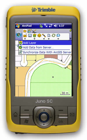
Podleski advised the team that the field crews could most efficiently and accurately collect data using several key pieces of hardware and software. The final setup was purchased from Wind Environmental Services. This firm was chosen because of its software development work integrating digital cameras with ArcPad and its strong background in mobile GIS. Garet Couch, business manager at Wind Environmental Services, recommended a solution that included the Archer Ultra-Rugged Field PC with an attached CompactFlash GPS receiver, GPS enabled PDA units manufactured by Juniper Systems; ArcPad; rugged Ricoh 500SE digital cameras; and Wind Image software by Wind Environmental.
HWA purchased one setup (both hardware and software) and had Perteet prepare it for a pilot test. The setup performed better than expected and had few drawbacks. Curb ramp and sidewalk data could be collected in less than five minutes per block-face. Eventually, once field teams were seasoned, that time was reduced to four minutes or less without sacrificing data collection accuracy.
Considerable effort went into the design of the back-end geodatabase that would handle all the inventory data. Perteet implemented the database back end in personal ArcSDE because it was an inexpensive way to implement versioning and database backup procedures that would require little database management overhead. Ultimately the database had to perform several key functions:
Define well-planned attribute domains that would show up as pick lists in ArcPad.
Store and manage all field data in a secure and recoverable environment.
Maintain the fundamental database table schema exported from the City of Seattle's Hansen asset management database.
Track completed block-face segments as the field crews progressed.
The GIS back end also needed to handle multiple geographically and temporally overlapping ArcPad data checkouts and provide an efficient method to run quality assessment analysis. While the ArcPad 7.0 checkout and check-in process leaves out some desirable functionality, it ultimately served its purpose by providing a way to check data out of the database and subsequently check it back in after the field crews finished updating it. Care was taken to ensure that, in most cases, two teams did not accidentally overlap collection efforts. This not only made the collection effort more efficient but also less prone to certain types of data loss that can occur when one team partially updates a block-face that another team already surveyed.
Managing Field Teams
Pearson from HWA assembled and managed the field crews, hired interns and organized 10 one- and two-person teams, then trained them to use the Archer data logger, Ricoh Camera, ArcPad, and the Wind Image setup. He also met with these teams daily to assign them to new data collection areas and transfer data to and from their handheld units and his field laptop. He also briefed them on the special challenges they might face in each new neighborhood and how to handle them in a standardized way.
HWA also led weekly retraining meetings with the crews to further ensure a standardized data collection approach across all teams. City of Seattle's project manager Benjamin Hansen attended several of these sessions. Pearson also maintained regular contact with his teams via cell phone and often performed on-the-fly tech support for the HWA teams. Ongoing technical support was supplied by Couch of Wind Environmental, who helped keep the crews up and running.
Many team meetings were held at Seattle's famous Wi-Fi coffeehouses. These were great places for performing data transfers while in the field. Pearson also maintained frequent contact with the Perteet GIS office to ensure that enough data would be available to keep all of the teams occupied and relay desired changes to the ArcPad setup, database design, work area definition, and other parameters of the GIS solution.
Data Transfer Strategies
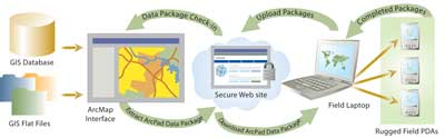
Additionally, Perteet thoroughly planned the data transfer and management process. ArcPad data packages needed to flow from the GIS office at Perteet to the field crews and back again. This transfer was handled through a secure Web site where new data packages were posted and retrieved as needed. HWA's field crew manager would typically access the site while visiting a WiFi-equipped establishment. While connected, he could download new data packages, upload completed data packages, and transfer data packages to and from each of the handheld units as they came in from the field via a USB connection.
The data packages followed a strict naming convention that explicitly stated the work area covered and purpose (i.e., collection or for quality assessment re-collection). All data packages were archived on both ends of the network to provide additional data security using managed redundancy.
Ensuring Data Quality
HWA and Perteet jointly implemented a quality assessment, reporting, and control program that covered more than 14 percent of the field-collected data. It is essential for a project of this size to include such a program. Without it, there are few meaningful ways to assess how well the field teams are performing or where the team manager needs to focus retraining efforts and stress methods for ensuring the teams collect data uniformly.
For instance, the assessment program successfully identified that some teams were collecting data for partially completed block-faces. Since the sidewalk segments defined by the Hansen database cover the entire block-face, the city preferred that the teams mark all partially improved block faces as unimproved. Fortunately, the quality assessment program identified this omission and retraining efforts corrected the problem.
The quality assessment program worked by sending a team into the field—typically with a blank set of block-face data—to re-collect information for a minimum of 10 percent of the block-faces in each neighborhood. This data was then sent back to the Perteet GIS office for processing in ArcInfo using several geoprocessing models run from ArcToolbox. The models compared the re-collected data, record by record, to previously collected data and output tables with a count of each type of difference for each field in the database. Perteet then compiled the differences from each neighborhood into a spreadsheet where additional statistics could be calculated. These statistics included the total number and percentage of conflicting values in the quality assessment areas, by error category, and as a whole.
Conclusion
HWA and Perteet completed the data collection effort ahead of schedule, within budget, and to a high level of accuracy. Among the many uses for this valuable inventory data, the city is prioritizing maintenance and new construction as well as supporting asset management efforts. The sidewalk and curb ramp inventory will serve as valuable input for the City of Seattle's upcoming pedestrian master plan. A second phase of data collection is planned and will focus on the condition of existing sidewalks. This phase will help the city locate and prioritize the sidewalk repairs on the basis of condition.
The Seattle Sidewalk and Ramp Inventory Project is an excellent example of the effectiveness of mobile GIS data collection techniques for accurate inventory of municipal facilities. Mobile GIS data collection is also useful for utility, engineering, and planning inventories of various types such as National Pollutant Discharge Elimination System (NPDES) stormwater inventories.
In today's world, knowing which facilities are located where is often critical to decision making across organizations and at many levels of society. Mobile GIS offers one of the best ways to efficiently gather this type of information into useful, effective spatial databases. For additional information, visit the Seattle Department of Transportation (SDOT) Web site at www.seattle.gov/transportation/